6 August 2008
The operations will include drilling of appraisal wells at Hook Head and Dunmore
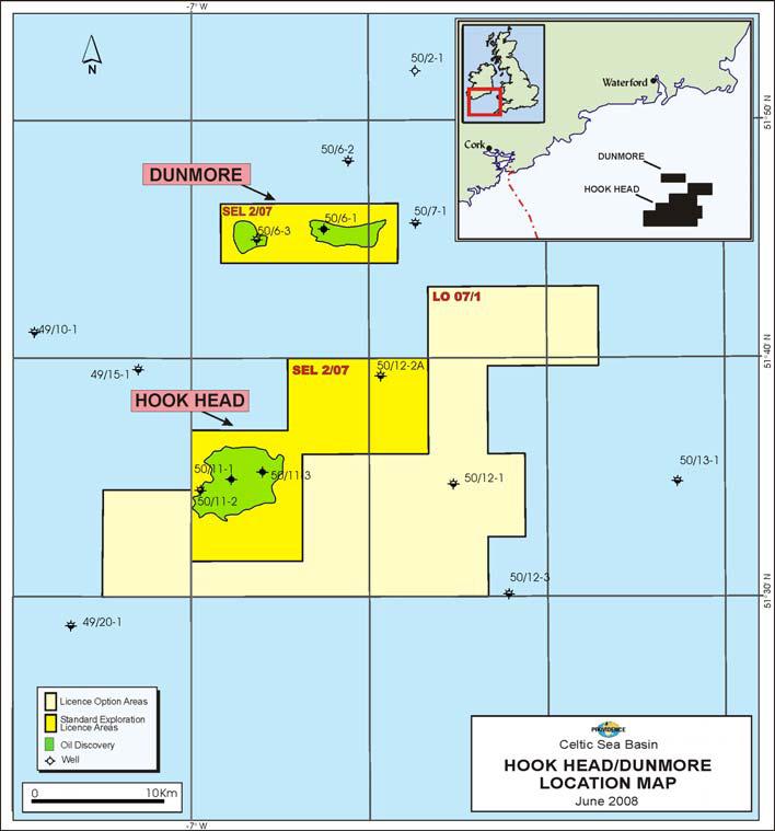
SOSINA and its partners have commenced drilling operations on their multi-well drilling programme on Standard Exploration Licence 2/07 in the North Celtic Sea Basin, offshore southern Ireland.
Using the Transocean GSF Arctic II semi-submersible rig, drilling operations on the initial Hook Head appraisal well (50/11-4) commenced at 12:00pm on Tuesday, August 5th.
Following completion of this well, a further appraisal well, (50/6-4), is planned to be drilled on the nearby Dunmore oil accumulation, located approximately 20 kilometres to the north of the Hook Head oil accumulation.
It is anticipated that the multi-well drilling programme will take up to 3 months, which includes a provision for a comprehensive wireline logging and testing programme.
The Standard Exploration Licence 2/07 partners and their respective percentages are Providence Resources Plc (Operator) 48.6556%, Challeneger Minerals (Celtic Sea) Limited 24.5%, Forest Gate Resources Inc. 8.3889%, Atlantic Petroleum (Ireland) Limited 12.3037% and SOSINA Exploration Limited 6.1519%.
Contacts:
Dr. David J. Davies Managing Director, CEO SOSINA Exploration Ltd 1 Berry St Aberdeen AB25 1HF Tel: +44 1224 845464 | Mr. John Ødegaard, Chairman of the Board Tel: +45 35 31 10 02 Mobile: +45 27 26 00 03
|
Map
Click on the map if you want to enlarge or download.
Notes to Editors
Celtic Sea Standard Exploration Licence 2/07
Standard Exploration Licence 2/07 refers to part blocks 49/22, 49/23, 48/29, 48/30, 49/26, 49/27, 49/28, 49/8, 49/9, 49/13, 49/14, 50/6, 50/7 & 50/11 in the North Celtic Sea Basin, offshore southern Ireland. The current Standard Exploration Licence 2/07 partners and their respective percentages are Providence Resources Plc (Operator) 48.6556%, Challenger Minerals (Celtic Sea) Limited 24.5%, Forest Gate Resources Inc. 8.3889%, Atlantic Petroleum (Ireland) Limited 12.3037% and SOSINA Exploration Limited 6.1519%.
About Hook Head
The Hook Head Field is located in c. 240' water depth being c. 60 km offshore Wexford and is situated in Standard Exploration Licence 2/07 in the North Celtic Sea Basin. The Hook Head structure is a large mid-basinal anticline where three previous wells have successfully encountered hydrocarbon bearing sands. The original 50/11-1 discovery well, which was drilled by Marathon in 1971, logged c. 100 feet of hydrocarbon bearing section in five sandstone units of Lower Cretaceous age. The well was not flow-tested due to severe operational issues at that time. The subsequent 50/11-2 appraisal well, which was drilled by Marathon in 1975 was drilled as a delineation well at the down-dip edge of the structure and encountered c. 25' of hydrocarbon bearing section.
In 2007, Providence drilled the 50/11-3 well on a central location some 2 km northeast of the 50/11-1 well and successfully logged a total of c. 110' of net hydrocarbon bearing reservoir. The reservoir zones are of equivalent age to those encountered in the 50/11-1 & 2 wells, located c. 2.5 km and c. 5 km to the south-west, respectively. Whilst key reservoir and fluid data were acquired during the initial well flowing period, down-hole mechanical conditions, which were primarily related to the integrity of the casing string cement bond, delayed the implementation of a full flow test programme. The 50/11-3 well was suspended for future re-entry and potential use as a production well.
About Dunmore
The Dunmore oil discovery is located in c. 70 metre water depth being c. 40 km offshore Wexford and is situated in Standard Exploration Licence 2/07 in the North Celtic Sea Basin. The 50/6-1 discovery well was drilled in 1986 by Gulf Oil (now part of Chevron), and tested a c. 60' gross interval at a rate of c. 2,100 BOPD from sands of Upper Jurassic age at a depth of c. 5,000' TVDSS. The oil is a light, sweet, 44o API crude and is interpreted to be trapped in a downthrown terrace structure. Mapping of reprocessed 2D seismic data now suggest that this structure rises to the east of the 50/6-1 well location and that an appraisal well would be optimally drilled c. 500' up-dip from the 50/6-1 well. On the assumption that a common contact exists between the 50/6-1 discovery well and this crestal area, a number of sands which were water bearing in the original well should be oil bearing at the crestal area thereby significantly increasing the potential flow rates.
About SOSINA
SOSINA Exploration Ltd. is an independent oil and gas exploration company. The Company was founded in 2004, but with roots back as a sister company to the company Odegaard Ltd. acquired in 2006 by Schlumberger Inc.
SOSINA's active oil and gas portfolio includes offshore interests in Ireland and the UK. SOSINA's portfolio is balanced between appraisal and exploration assets. Comprehensive information on SOSINA and its oil and gas portfolio is available from SOSINA's website at www.sosina.co.uk.