Drilling of Hook Head well completed
27 August 2008
Hydrocarbon presence at well 50/11-4 was substantially less than expected. Dunmore drilling operations 20 km further north are expected to start within 10 days
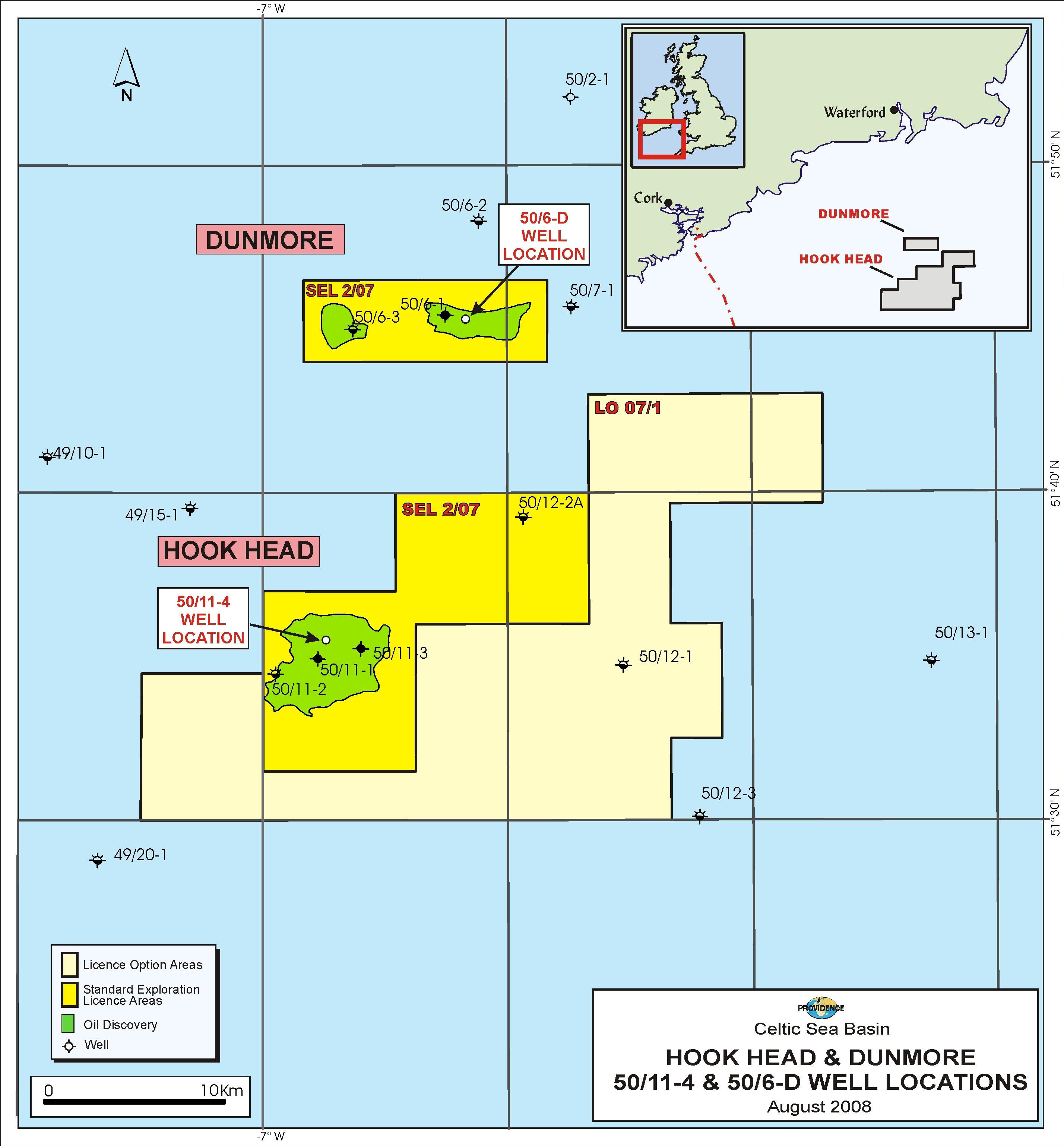
Providence Resources and its partners including SOSINA has concluded the appraisal drilling operation on the north-west flank of its Hook Head oil discovery in Standard Exploration Licence 2/07 in the North Celtic Sea Basin, offshore southern Ireland. Drilling operations on its nearby Dunmore oil discovery is now being prepared and is expected to start within 10 days.
The Hook Head appraisal well (50/11-4) was drilled on the north-west flank of the Hook Head structure using the Transocean semi-submersible GSF Arctic II rig and was spudded on August 5th, 2008. The well was successfully drilled to a total depth (TD) of 4,875 feet true vertical depth subsea (TVDSS). All geological horizons in the Wealden sand package were within the pre-drill depth prognosis and oil and gas shows were encountered whilst drilling. The well encountered 30 feet of net hydrocarbon bearing Lower Cretaceous sands above the primary objective, which is of an equivalent age to those logged as being hydrocarbon bearing in the 50/11-3 well, located c. 2.3 km to the south-east. Reservoir quality across these intervals was excellent with average porosities of c. 27%. This well constitutes the fourth well to be drilled on the Hook Head structure, all of which have logged hydrocarbons.
However, given that the net hydrocarbon bearing intervals in the 50/11-4 well were substantially less than that which was expected in the pre-drill estimates, Providence and its partners took the decision to plug and abandon the 50/11-4 well. The initial well results suggest that the majority of the Hook Head resource lies in the central part of the structure already demonstrated by the 50/11-1 and 50/11-3 wells, however, the north-west flank could potentially provide additional incremental resources for any future development in the area. The 50/11-4 well results will now be integrated into the Hook Head full field model before finalising forward plans for the accumulation.
In the meantime, and as per programme, the process to move off Hook Head and mobilise the Arctic II drilling unit to the Dunmore oil appraisal well (50/6-D), located approximately 20 kilometres to the north of Hook Head has now started.
 | |
The rig is now moved from Hook Head to Dunmore. |
Contacts:
Dr. David J. Davies Managing Director, CEO SOSINA Exploration Ltd 1 Berry St Aberdeen AB25 1HF Tel: +44 1224 845464 | Mr. John Ødegaard, Chairman of the Board Tel: +45 35 31 10 03 Mobile: +45 27 26 00 03
|
Notes to Editors
Celtic Sea Standard Exploration Licence 2/07
Standard Exploration Licence 2/07 refers to part blocks 49/22, 49/23, 48/29, 48/30, 49/26, 49/27, 49/28, 49/8, 49/9, 49/13, 49/14, 50/6, 50/7 & 50/11 in the North Celtic Sea Basin, offshore southern Ireland. The current Standard Exploration Licence 2/07 partners and their respective percentages are Providence Resources Plc (Operator) 48.6556%, Challenger Minerals (Celtic Sea) Limited 24.5%, Forest Gate Resources Inc. 8.3889%, Atlantic Petroleum (Ireland) Limited 12.3037% and SOSINA Exploration Limited 6.1519%.
About Dunmore
The Dunmore oil discovery is located in c. 70 metre water depth being c. 40 km offshore Wexford and is situated in Standard Exploration Licence 2/07 in the North Celtic Sea Basin. The 50/6-1 discovery well was drilled in 1986 by Gulf Oil (now part of Chevron), and tested a c. 60' gross interval at a rate of c. 2,100 BOPD from sands of Upper Jurassic age at a depth of c. 5,000' TVDSS. The oil is a light, sweet, 44o API crude and is interpreted to be trapped in a downthrown terrace structure. Mapping of reprocessed 2D seismic data now suggest that this structure rises to the east of the 50/6-1 well location and that an appraisal well would be optimally drilled c. 500' up-dip from the 50/6-1 well.
On the assumption that a common contact exists between the 50/6-1 discovery well and this crestal area, a number of sands which were water bearing in the original well should be oil bearing at the crestal area thereby significantly increasing the potential flow rates.
About Hook Head
The Hook Head Field is located in c. 240' water depth being c. 60 km offshore Wexford and is situated in Standard Exploration Licence 2/07 in the North Celtic Sea Basin. The Hook Head structure is a large mid-basinal anticline where three previous wells have successfully encountered hydrocarbon bearing sands. The original 50/11-1 discovery well, which was drilled by Marathon in 1971, logged c. 100 feet of hydrocarbon bearing section in five sandstone units of Lower Cretaceous age. The well was not flow-tested due to severe operational issues at that time. The subsequent 50/11-2 appraisal well, which was drilled by Marathon in 1975 was drilled as a delineation well at the down-dip edge of the structure and encountered c. 25' of hydrocarbon bearing section.
In 2007, Providence drilled the 50/11-3 well on a central location some 2 km northeast of the 50/11-1 well and successfully logged a total of c. 110' of net hydrocarbon bearing reservoir. The reservoir zones are of equivalent age to those encountered in the 50/11-1 & 2 wells, located c. 2.5 km and c. 5 km to the south-west, respectively. Whilst key reservoir and fluid data were acquired during the initial well flowing period, down-hole mechanical conditions, which were primarily related to the integrity of the casing string cement bond, delayed the implementation of a full flow test programme. The 50/11-3 well was suspended for future re-entry and potential use as a production well.
« Back