Drilling operations at Dunmore commenced 5 September 2008
8 September 2008
The new well is designed to prove additional volumes in the Dunmore accumulation
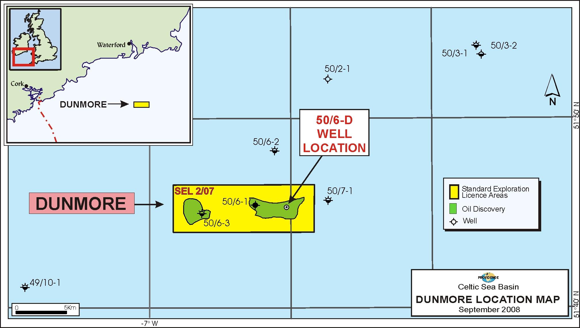
Providence and its Celtic Sea partners inclusive SOSINA have commenced appraisal drilling operations on their Dunmore oil discovery in Standard Exploration Licence 2/07 in the North Celtic Sea Basin, offshore southern Ireland.
Using the Transocean semi submersible GSF Arctic II rig, drilling operations on the Dunmore appraisal well (50/6-4) commenced at 07:45am on Friday, September 5th. It is anticipated that the drilling programme will take up to 40 days, which includes a provision for a comprehensive wireline logging and testing programme. The appraisal well 50/6-45 is located up-dip from the original tested Jurassic discovery well 50/6-1 and is designed to prove additional volumes in the Dunmore accumulation.
 | |
Drilling of well 50/6-1 at Dunmore has commenced. |
Contacts:
Dr. David J. Davies Managing Director, CEO SOSINA Exploration Ltd 1 Berry St Aberdeen AB25 1HF Tel: +44 1224 845464 | Mr. John Ødegaard, Chairman of the Board Tel: +45 35 31 10 03 Mobile: +45 27 26 00 03
|
Notes to Editors
Celtic Sea Standard Exploration Licence 2/07
Standard Exploration Licence 2/07 refers to part blocks 49/22, 49/23, 48/29, 48/30, 49/26, 49/27, 49/28, 49/8, 49/9, 49/13, 49/14, 50/6, 50/7 & 50/11 in the North Celtic Sea Basin, offshore southern Ireland. The current Standard Exploration Licence 2/07 partners and their respective percentages are Providence Resources Plc (Operator) 53.111, Challenger Minerals (Celtic Sea) Limited 26.743%, Atlantic Petroleum (Ireland) Limited 13.430% and SOSINA Exploration Limited 6.715%.
About Dunmore
The Dunmore oil discovery is located in c. 70 metre water depth being c. 40 km offshore Wexford and is situated in Standard Exploration Licence 2/07 in the North Celtic Sea Basin. The 50/6-1 discovery well was drilled in 1986 by Gulf Oil (now part of Chevron), and tested a c. 60' gross interval at a rate of c. 2,100 BOPD from sands of Upper Jurassic age at a depth of c. 5,000' TVDSS. The oil is a light, sweet, 44o API crude and is interpreted to be trapped in a downthrown terrace structure. Mapping of reprocessed 2D seismic data now suggest that this structure rises to the east of the 50/6-1 well location and that an appraisal well would be optimally drilled c. 500' up-dip from the 50/6-1 well.
On the assumption that a common contact exists between the 50/6-1 discovery well and this crestal area, a number of sands which were water bearing in the original well should be oil bearing at the crestal area thereby significantly increasing the potential flow rates.
« Back