4 March 2014
The programme will be pursued by Polarcus using one of their high-end "A" class 3D vessels.
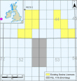
SOSINA Exploration Ltd is pleased to announce a major new 3D seismic programme, which is planned to be acquired by Polarcus, subject to statutory assessment, in the southern Porcupine Basin, offshore south-west Ireland. This non-exclusive multi-client survey, which is planned to commence this summer, will cover the deep-water Drombeg exploration prospect that is located in Frontier Exploration Licence (FEL) 2/14 (?Drombeg Licence'). The Drombeg Licence, which is situated in c. 2,500 m water depth and c. 220 km off the west coast of Ireland is operated by Providence Resources (80%) on behalf of SOSINA (20%). Providence and SOSINA recently converted Licensing Option (LO) 11/9 into FEL 2/14.
The total planned seismic acquisition programme will cover a minimal area of 3,200 km2, which will include c. 1,065 km2 over the Drombeg Licence. Under the terms of the recently executed agreement, Providence and SOSINA have agreed to licence a total of 2,250 km2 of data, which will include the area over the Drombeg Licence and adjacent open acreage for a fixed sum. This 3D seismic programme will fulfil the seismic data acquisition work programme obligations for the first phase of FEL 2/14. Polarcus plans to carry out the seismic acquisition programme using one of their high-end "A" class 3D vessels.
Providence and SOSINA expect that these new high resolution 3D data over our Drombeg prospect will confirm the potential, which has been identified within the Lower Cretaceous section and will allow for the commencement of well planning on Drombeg. These data will also allow Providence and SOSINA to evaluate the potential in the stacked Jurassic and Paleocene levels where significant addition exploration prospectivity has been identified.
Providence and SOSINA expect that these new high resolution 3D data over our Drombeg prospect will confirm the potential, which has been identified within the Lower Cretaceous section and will allow for the commencement of well planning on Drombeg. These data will also allow Providence and SOSINA to evaluate the potential in the stacked Jurassic and Paleocene levels where significant addition exploration prospectivity has been identified.
| Contact: |
Mr. John Ødegaard, Chairman of the Board Mobile: +45 27 26 00 03 |
The Drombeg area | About Drombeg
The Drombeg prospect lies in c. 2,500 metre water depth and is c. 3,000 metres below the seabed. The prospect is located in the southern Porcupine Basin, c. 220 km off West Cork, being c. 60 km from the ExxonMobil-operated Dunquin exploration prospect which was drilled in mid-2013. As operator Providence Resources completed in 2012 a major seismic inversion programme over the Lower Cretaceous Drombeg prospect, together with an assessment of its associated prospective resource potential. Initial rock physics modelling and seismic inversion work was carried out by Ikon Science over key 2D Drombeg seismic lines, which exhibited a marked seismic anomaly. This initial work modelled the Drombeg anomaly to be consistent with the presence of thick hydrocarbon bearing sandstone intervals.
At that time, it was also confirmed that a large Jurassic fault block closure, with a pronounced crestal fluid escape feature, had been also identified beneath the Drombeg Lower Cretaceous prospect. Results from the inversion study, together with a volumetric analysis of the Lower Cretaceous interval, has indicated a recoverable P50 prospective resource potential of 872 MMBO, based on oil in place volume of 2.970 BBO.
Two separate stratigraphic, but vertically stacked objectives have also been identified in the overlying Lower Cenozoic and underlying Upper Jurassic. The Lower Cenozoic feature is interpreted to comprise a deep-water basin floor fan covering c. 295 sq km and which exhibits marked amplitude versus offset (AVO) anomaly. The deeper Upper Jurassic feature is mapped as a large tilted fault block structure with c. 140 sq km of closure. A notable fluid escape feature has been interpreted at the crest of the Upper Jurassic tilted fault block and which appears to be acting as a hydrocarbon migration path into both the overlying Drombeg Lower Cretaceous and Lower Cenozoic target intervals. This fluid escape feature is significant in that it suggests an oil remigration model at Drombeg, which is similar to that which has been proposed for the BP-operated Foinaven and Schiehallion Fields in the UK West of Shetlands. |
About SOSINA
SOSINA Exploration Ltd. is an independent oil and gas exploration company. The Company was founded in 2004, but with roots back as a sister company to the company Odegaard Ltd. acquired in 2006 by Schlumberger Inc.
SOSINA's active oil and gas portfolio includes offshore interests in Ireland and the UK. SOSINA's portfolio is balanced between appraisal and exploration assets. Comprehensive information on SOSINA and its oil and gas portfolio is available from SOSINA's website at www.sosina.co.uk.