Significant hydrocarbons in the Hook Head appraisal well
10 September 2007
SOSINA and its partners have encountered significant hydrocarbons in the Hook Head appraisal well. The well flow testing programme will commence soon
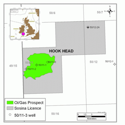
The Providence Resources Plc. operated 50/11-3 Hook Head appraisal well has successfully logged a total of 75 feet of net hydrocarbon bearing reservoir in the 50/11-3 Hook Head appraisal well, offshore Ireland. This well, which is located in 240 feet water depth and is c. 60 km offshore Waterford, is situated in Standard Exploration Licence 2/07 in the North Celtic Sea Basin. The well was drilled to a total depth (TD) of 4,880 feet true vertical depth subsea (TVDSS). All geological horizons were encountered within the pre-drill depth prognosis and significant oil and gas shows characteristic of either a light oil or rich gas were encountered whilst drilling.
Preliminary petrophysical analysis of electric wireline logs acquired over the main Lower Cretaceous target indicates a 484 foot gross hydrocarbon bearing interval. The reservoir zones are of equivalent age to those encountered in the 50/11-1 & 2 wells, located c. 2.5 km and c. 5 km to the south-west, respectively. Initial analysis of the data suggests an overall improvement in reservoir quality at the 50/11-3 location, with average porosities of 20% within the main hydrocarbon bearing interval. In addition to the successful appraisal of the accumulation, a number of further exploration objectives were also logged as hydrocarbon bearing in the well. The plan is now to set a string of casing prior to flow testing the well.
Upon completion of drilling operations, the revised* equity ownership in the Hook Head discovery is Providence Resources Plc (Operator) 43.5294%, Challenger Minerals (Celtic Sea) Limited 16.3235%, Dyas BV 16.3235%, Atlantic Petroleum (Ireland) Limited 10.8824%, Forest Gate Resources Inc. 7.5%, SOSINA Exploration Limited 5.4412%. These revisions are subject to Ministerial approval.
About Hook Head
The Hook Head structure is a large anticline where two previous wells have successfully encountered hydrocarbon bearing sands. The original IRL50/11-1 discovery well, which was drilled by Marathon in 1971.The well was not flow-tested due to severe operational issues at the time. The subsequent IRL50/11-2 appraisal well, which was drilled by Marathon in 1975 was drilled as a delineation well at the down-dip edge of the structure.
Post-drill mapping by Marathon indicates that the crest of the structure is located to the north-east of the IRL50/11-1 discovery well, which is further supported by the seismic data acquired by Providence in 2006. This crestal location is some 2.5 km northeast of the IRL50/11-1 well and is thought to be c. 70 metres structurally higher than the original well. Pre-drill in-house volumetric estimates suggested that the Hook Head discovery could contain prospective resources of up to c.70 MMBO or 250 BSCFG REC.
Map
 |
Hook Head |
Larger map? Click here >> |
Contacts
David J. Davies
Managing Director
SOSINA Exploration Ltd
Mob: +44 (0)7703 293 649
Golden Cross House
8 Duncannon Str
London WC2N 4JF
Tel: +44 (0)207484 5071
Fax +44 (0)20 7884 5100
1 Berry St
Aberdeen
AB25 1HF
Tel: +44 1224 845464
| Document | Size | Format | |
| Text | 10 KB | RTF | Download >> |
| License map | 78 KB | GIF | Download >> |
| Hook Head | 45 KB | GIF | Download >> |
« Back