A seismic survey comprising 2,500 kilometres of long offset 2D seismic data is planned to commence in August 2014 in the Newgrange area
12 August 2014
The programme is designed to enhance subsurface imaging and advance the planning of an exploration well on the project
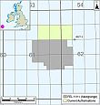
SOSINA Exploration Ltd is pleased to provide an update on Frontier Exploration Licence ("FEL") 6/14 ("Newgrange"). SOSINA Exploration (20%) and Providence Resources (80%, Operator) were originally awarded a licensing option over Newgrange as part of the 2011 Irish Atlantic Margin Licensing Round. Earlier this year, with the agreement of the Department of Communications, Energy and Natural Resources, the licensing option was converted into FEL 6/14. The Newgrange area lies in c. 1,000 metre water depth in the Goban Spur Basin and is c. 260 km off the south west coast of Ireland.
As operator Providence has - on behalf of both partners - agreed a contract with Polarcus MC Limited and Seabird Exploration for the provision of 2,500 line kilometres of new "state of the art" long offset 2D seismic reflection data in the Newgrange area. Approximately 1,000 line kilometres will be focused on the Newgrange prospect, together with associated seismic well tie lines. The survey is currently planned to commence in August 2014 and will be acquired using the M/V Harrier Explorer. This regional 2D seismic programme will also tie into Polarcus' South Porcupine MC3D survey which is ongoing over the Drombeg area and where approximately 3,000 km2 of prime data have already been acquired. The survey will also tie the Dunquin North exploration well, which has proven an oil exploration play concept in Cretaceous-aged carbonates in the area.
Previous subsurface studies have highlighted both clastic and carbonate exploration prospectivity at Newgrange within the Jurassic and Cretaceous intervals, respectively. Seismic interpretation of existing 2D reflection profile data has revealed the presence of two large stacked four-way structural closures at Base Cenozoic (Top Cretaceous) and Base Cretaceous (Top Jurassic) levels covering up to a c. 1,200 km2 area. The previously drilled well No. 62/7-1, which is located c. 30 km from the Newgrange prospect and was drilled off-structure, encountered hydrocarbon shows in sands of Lower Jurassic age.
| Contact: |
Mr. John Ødegaard, Chairman of the Board Mobile: +45 27 26 00 03 |
Newgrange, FEL area | About Newgrange
Read more about Newgrange on the SOSINA website. Click on the illustration at the left. |
« Back